Scattered across various online skiing forums, overheard in lift lines, and discussed on the skin track are conversations about the problems facing skiing in the PNW and potential solutions for the future. I have been participant to my fair share of these but they have always felt to me as being light on specific details and lacking a unified vision. As such, the desire was created to assess the depth of the problems and feasibility of the solutions to the problems we face around access to our mountains. The end goal being the establishment of my vision for the future of skiing in the PNW.
Previously in this series I wrote about how the Cascades snowpack is responding to climate change, what prevented expansion of our ski areas, and where our existing ski areas could expand. The theme of these being that skiing in the PNW is facing the following major issues:
- Washington’s rapidly growing population causing overcrowding at existing ski areas
- Corporate consolidation leading to ski area owners not having the sport’s best short or long term interests in mind
- Climate change causing some existing areas to become nonviable in the foreseeable future
- The lack of potential expansion locations due to land use restrictions
The conclusion of all this being that in order to meet demand while keeping our mountains and winter recreation accessible Washington needs to consider the possibility of an entirely new ski area. Specifically, there are four areas of focus that would go a long way to providing sufficient access not just for mechanized skiers, but backcountry skiers, snowshoers, and general snow play (sledding for children and families):
- Expansions of existing ski areas (see my previous post for details on this point)
- Creation of a new ski area to provide competition to the large ski corporations
- Winter maintenance to high elevation trailheads for ski touring, snowshoeing, and sledding
- Increased focus on winter recreation community groups for ongoing advocacy
This final post attempts to answer the feasibility of doing so. Mainly, why is a new ski area needed, where could it be located, how would it be funded, and how would it operate?
After publishing my previous post on land use restrictions and access issues in the Cascades I had some conversations with other folks whom share the same concerns. What I’ve learned from these conversations is that many of the same access issues discussed here extend to other sports and summertime activities as well. Even if you’re not a skier, if you use our mountains for any type of recreation these access issues affect you too. While I focus on skiing and winter recreation here to avoid blowing up the scope of this writing, keep in mind that these issues of overcrowding and access certainly apply to our summer trailheads as well.
Disclaimer & Scope of Research
First, I always start these with a disclaimer: I am not a civil engineer, surveyor, ski area operator, or anyone with a background in or credibility on the topics discussed on this page. I am just a passionate skier who loves the PNW and wants to explore how the problems facing ski culture here could be addressed. I am always open to constructive criticism if you have input on anything I missed or are interested in these topics and want to discuss them further. Please reach out if so (see email in header).
Second, and to be clear, all of this is primarily a thought exercise. As much as I would love to see any of the proposals below come to fruition, I am not naive enough to think that we’ll have a new ski area in the Cascades any time soon, or ever really. It is disappointing that this is the default mentality we operate with. We know there are recreational access problems in our mountains but instead of the response to those being “how can we expand access to fix it?” it is instead “that won’t happen” and is dismissed. My writing here is therefore done from a place of optimism where I explore solutions to these problems that could be brought to fruition given sufficient motivation and political will.
Keep in mind when reading everything below that these are simply ideas. Some are fairly feasible while others are are pie-in-the-sky ideas which are effectively only exploring the idea. We would not need all of this, at least not all at once. In reality, expanding our existing ski areas is the far more realistic scenario. But it’s fun to explore what could be, so let’s do it.
Why do we need a new ski area?
In the early 1930s a local skier, Veida Morrow, spent a few days skiing the mountains around Snoqualmie Pass with her brother and friends. Afterwards she wrote describing one part of the trip traveling down to a cabin at Goldmyer Hot Springs:
Then for four miles downhill running, carefree and as happy as the winds that flew with us. Gone and far behind—the noise and clamor of the city. Not even the beasts of the forests trespassed upon this ground we were skimming. Forgotten all the petty sordid things that ever surround one in this greedy rush to exist among the smokestacks of the city, for here, in the covert of the towering, unchanging mountains, for a few brief days, we lived.1
Putting aside everything else for a moment, it is worth noting the value of winter recreation in our mountains. As Veida put it, the opportunity to get away from the city and live among the humbling mountains for even a few days gives one a new perspective on life. This is an opportunity we should all have. While factors are putting this at risk, the overarching theme is we need ski areas to grant the opportunities for those who choose to partake in winter recreation to have the same experience as Veida and feel that they truly lived even for brief periods of time.
All of my previous posts on the topic of the future of skiing in the PNW have been around exploring what challenges we face are and how they may manifest themselves in the future. To reiterate from above, these are:
- Climate change will negatively affect our existing ski areas.
- Corporate consolidation of ski areas is pricing many existing and would-be skiers out of winter recreation in general.
- Overcrowding at existing ski areas due to growing popularity of winter sports and an ever growing population in Washington.
- Land use laws greatly limit potential expansion of both existing ski areas and a theoretical new ski area.
Let’s summarize some key points around each of these challenges to establish why a new ski area is not only warranted but necessary.
Climate Change
None of these conversations around skiing matters in the first place if climate change is going to affect the snowpack in the Cascades to the point that we don’t have skiing here at all anymore. Fortunately, this is likely not going to be case. I previously did a deep analysis into snowpack trends in the Cascades with data stretching back over 100 years and analyzing peer reviewed studies on the Cascades snowpack. The final takeaway from this analysis being:
The Cascades have experienced a ~20% decline of snowpack from 1930 - 2022 at a rate of 2% per decade. However, this is primarily limited to low elevations below 4,000ft and is due to increased temperatures rather than decreased precipitation. At high elevations (>4,000ft) the snowpack has not seen these large declines for now but increasing global temperatures and natural variability will begin to, potentially rapidly, affect these elevations in the coming decades.
As a small sample of this analysis, our snowpack at the higher elevations used for skiing (>4,000ft) is stable. Consider the snowdepth per year at Paradise (5,425ft):
Moreover, the length of our ski seasons show no statistically significant decline either. The daily snowdepth at Paradise:
Filter by decade:
There is a big caveat to this, however. Year to year natural variability as well as decades long variability have a significant affect on our climate. This variability combined with ever increasing global temperatures means our lower elevation ski areas are more and more at risk each year. As such, any future ski areas should prioritize higher elevations above all else for them to remain economically viable as the world (hopefully) transitions to carbon free/neutral forms of energy. But even with +2°C of warming the high elevation locations in the Cascades will still have sufficient snowfall for skiing. Beyond +2°C however and, well, we’re going to have bigger problems to worry about than where to find some fresh snow.
The other looming issue is Snoqualmie Pass. It is the lowest elevation ski area in Western Washington at ~3,000ft. As I explored in my snowpack analysis post, Snoqualmie is already seeing snowpack declines unlike other ski areas in the Cascades. Given how much of the Seattle population it serves we should be thinking about if/where its capacity will be moved to. By 2050 it’s likely there will be insufficient snowpack for skiing there.2 The economic viability of the ski area will likely founder well before then, potentially as soon as the 2030s. As this happens it will create even more stress on the higher elevation ski areas as displaced skiers migrate to new mountains. Given how long it takes ski area expansions to come to fruition (decades) we need to start planning for this now.
Corporate Consolidation
It is no secret that in the past ~20 years the ski industry has undergone a tremendous amount of consolidation. Namely, by four companies: Vail, Alterra, Boyne Resorts, and POWDR Corporation. The ski areas near Seattle are all owned by one of these companies:
- Stevens Pass: Vail
- Crystal Mountain: Alterra
- The Summit at Snoqualmie: Boyne Resorts
Fortunately, we do have some still independent mountains: Mt. Baker, Mission Ridge, and White Pass. These are all smaller than the corporation owned mountains and are lengthy drives from the major population center of Seattle making them more suited to serving their local communities.
There is much to be said on the ethics around treatment of employees of some of these companies. Nearly all skiers around Seattle know all too well about the issues that have plagued Stevens Pass since the 2018 Vail acquisition. Much has been said about these issues so I will not cover them here. The operational issues run deep and it remains to be seen if the attempts to address them will result in any meaningful changes.
Aside from short term operational issues, the longer term danger I believe these ski corporations represent is that they do not have the sport’s best long term interests in mind. After all, their only real goals are to provide returns for their shareholders. Let’s focus on Vail here for example. Vail’s business model operates around a few key points:
- Market towards the top 3% of household income.3 Anyone in the middle class does not matter to them.

- Sell as many Epic passes as possible to create a stable and predictable revenue stream to hedge against poor snow conditions in a given year.4
- Part of the reason why day tickets are so expensive is because Vail does not want that revenue. They want all of their customers to be on what they call a “subscription tier” similar to a video streaming service. The day ticket prices are so expensive specifically to turn away anyone that has not bought into the Epic Pass ecosystem. Vail tells their investors they want 75% of revenue to come from advance sales specifically.
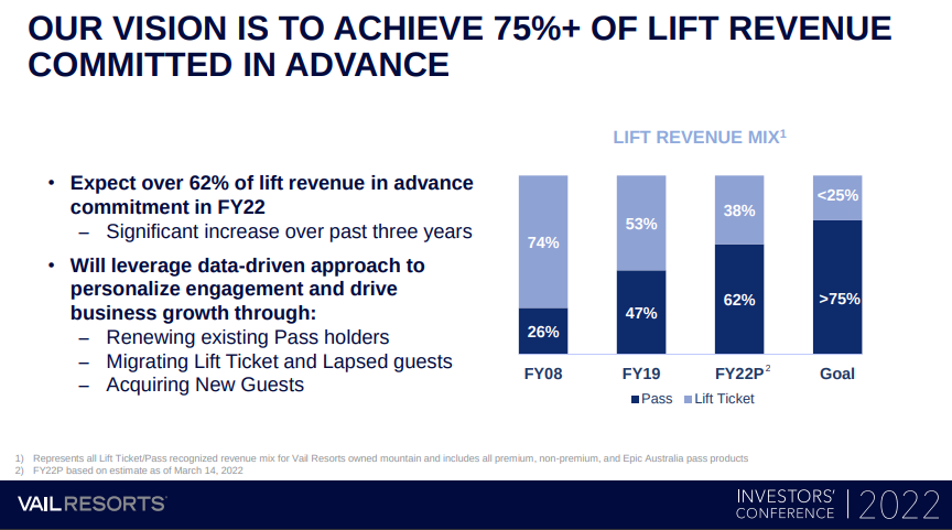
- Part of the reason why day tickets are so expensive is because Vail does not want that revenue. They want all of their customers to be on what they call a “subscription tier” similar to a video streaming service. The day ticket prices are so expensive specifically to turn away anyone that has not bought into the Epic Pass ecosystem. Vail tells their investors they want 75% of revenue to come from advance sales specifically.
- Leverage network effects to keep skiers within their network all season long.
- This requires the acquisition of smaller, local mountains to drive traffic to their destination, high margin mountains.
The creation of these network passes combined with the lock-in effects of the networks and the near impossibility for new competing ski areas to open has removed any incentive for Vail and crowd to provide a quality mountain experience. Their revenue is driven directly by how many passes they sell and how many people they can get on-site at their premiere, destination mountains. Your local mountain that was bought by Vail only serves as part of a pipeline to upsell you to their other more expensive properties. There is no incentive to upgrade or improve these local ski areas beyond the bare minimum required to keep them operating since they already have your money before the season starts.
In fact, the inability for new ski areas to open is viewed as a positive by Vail.5 They tell their investors the lack of new ski areas forces the market into their existing properties. The more of these that they acquire the stronger that lock-in effect becomes with no way to reduce it since it’s effectively impossible for new players to enter the market. By not allowing new ski areas to open we are playing right into the corporate hands of the ski corporations. We are giving them an oligopoly allowing them to extract ever higher profits.
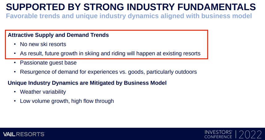
When it comes to Western Washington, the lack of inventive to upgrade and expand ski areas means that the only way to deal with the demand for skiing is to raise prices even further, which they are more than happy to oblige. This results in an ever increasing amount of people being priced out of the sport. Winter sports have never been cheap with high up-front costs for gear and ongoing transportation costs to get to the mountain but thanks to lift ticket prices it is becoming dramatically more unattainable to anyone in the middle class.
Ask yourself, what is the future of this sport when a day ticket, gear rental, and lesson for one person is over $500? Then multiply that by four for a family with two children. This is the real danger the corporate consolidation and their greed presents in my opinion; that we are at the start of pricing out a future generation of snow sports. What does skiing look like 20 years from now when that generation grows up and their interests lie elsewhere?
Overcrowding & Population Growth
As I discussed in my previous post, Washington’s population has grown by 50% since 1990 with another 30% expected by 2050.5 This growth tracks nearly identically with ski visits to our ski areas. That is, from 3M to 4.5M visits from 1996 to 2021.6 Extrapolating that trend, are we prepared to handle another 30% increase in demand on our ski areas over the next 30 years?
The lack of expansions over the previous 30 years has resulted in our existing ski areas being vastly overcapacity to the point of turning away customers and raising ticket/pass prices to help control crowds. In order to simply keep track with population growth our ski capacity needs to expand or we run the risk of pricing out large swaths of the population from winter sports. This is not just an issue with skiing either; given Washington’s lack of winter mountain access it extends to all types of winter recreation. Western Washington has effectively only seven reliable snow access points. Even if you are not a skier, you have to contend with the crowds to enjoy any type of winter recreation. This includes snowshoers or families that want go sledding with their children (Paradise being the only not overcrowded option for these activities but one that still requires the purchase of a pass for entry to the park).
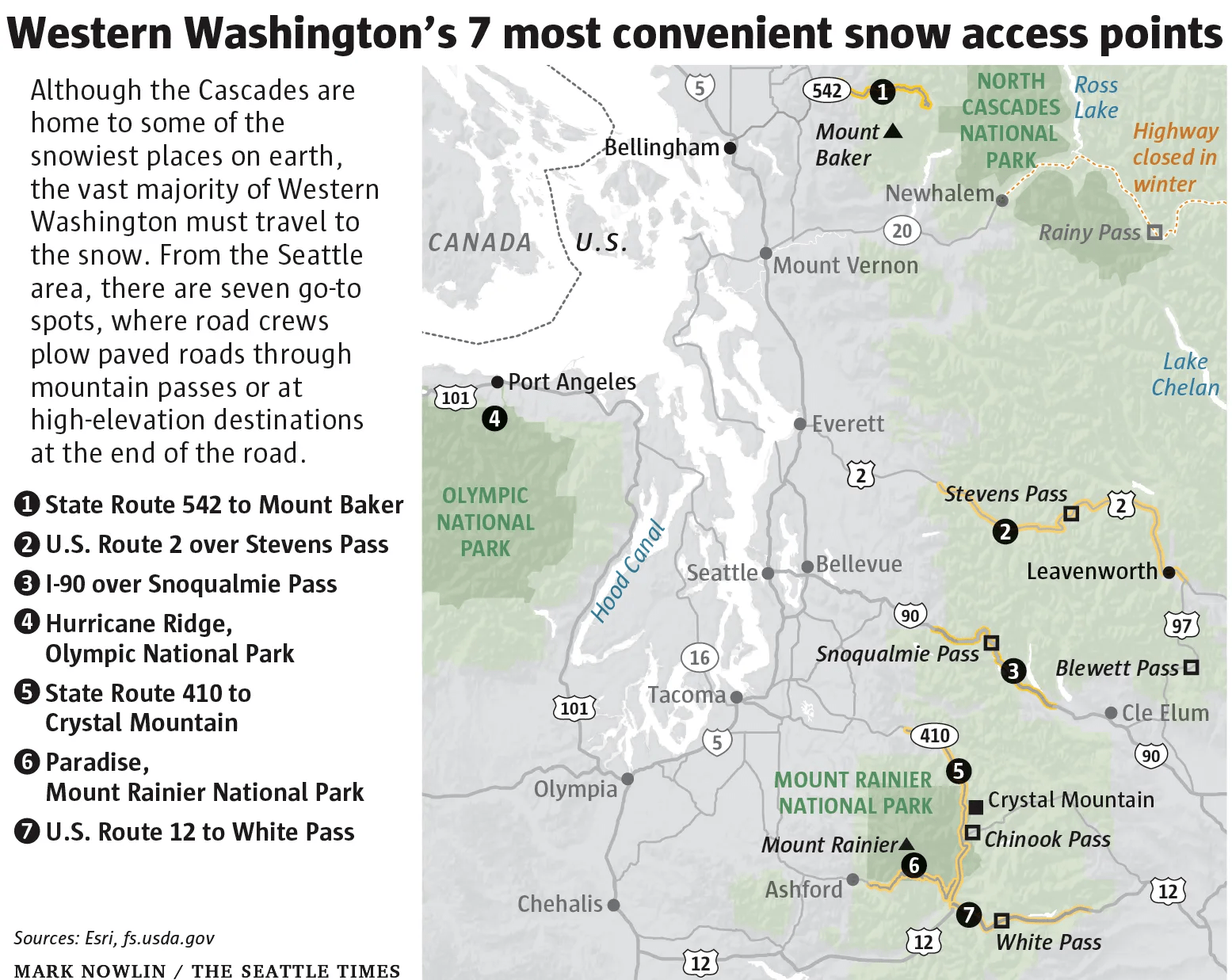
Unlike other western US states, winter access to the Cascades is sparse and difficult. Those seven snow access points create severe bottlenecks by funneling virtually all recreation traffic into them each weekend and with limited parking options. Compare this to summer where recreational traffic is dispersed between hundreds of trailheads and campsites and parking is much less of an issue since there’s no snow to worry about plowing. This is understandable given the different nature of those activities; it’s not to say we should have an equal number of winter access points as summer, but rather that winter access is severely limited and the opening of a few more snow access points would greatly benefit the public and increase our winter access capacity in the winter substantially.
Overall, the take away is that our ski areas and snow access points in general are vastly overcapacity. With more population growth in the future, we need to consider solutions to meet or at least try to keep up with demand let alone catch up to where we should be to handle the present demand.
Land Use Restrictions & Wilderness Area Classification
The biggest challenge of a new ski area in the Cascades is finding a location to place it. When I first started satisfying my curiosity about where a new ski area could go I figured I’d identify a bunch of possible and exciting locations. Months later and having learned about how restricted the Cascades have become over time the unfortunate reality is that there is not a single such location I can pinpoint. This is because there are nearly zero locations of sufficient elevation that are not in protected wilderness or roadless areas in the western Cascades.
I wrote about the problem of land restrictions in depth in my previous post on the politics of ski areas and why it’s so difficult to get more access for winter recreation in the Cascades. In short, vast swathes of land in the Cascades are designated as wilderness areas as defined by the 1964 Wilderness Act and subsequent 1984 Washington State Wilderness Act (plus a few others). For those unfamiliar with the concept of wilderness areas, a wilderness area is land designated by Congress that may not be developed or have any mechanized use on under any circumstances (with very limited exceptions). Short of an act of Congress, they are closed to development permanently.
Wilderness areas are wonderful for preservation and recreation for avid outdoorsmen. We are fortunate in Washington to have so much of our mountains protected by them. However, they do pose a challenge for winter sports. This is because nearly all of the high elevation land in the western Cascades that would be suitable for skiing is designated as wilderness. In some existing ski areas, such as Stevens Pass and Crystal Mountain, it is possible to expand them without encroaching on wilderness land, but in others, such as Mt. Baker or Alpental, it is not. If a new ski area were to ever be developed here it would be exceedingly difficult to do it purely on unprotected forest service land.
This is not a new concern either. As early as 1966 some in the industry were raising the same concerns about how the then would-be wilderness areas in the Cascades would dramatically limit ski area development in the future and the state’s ability to keep pace with demand for skiing with its population growth.
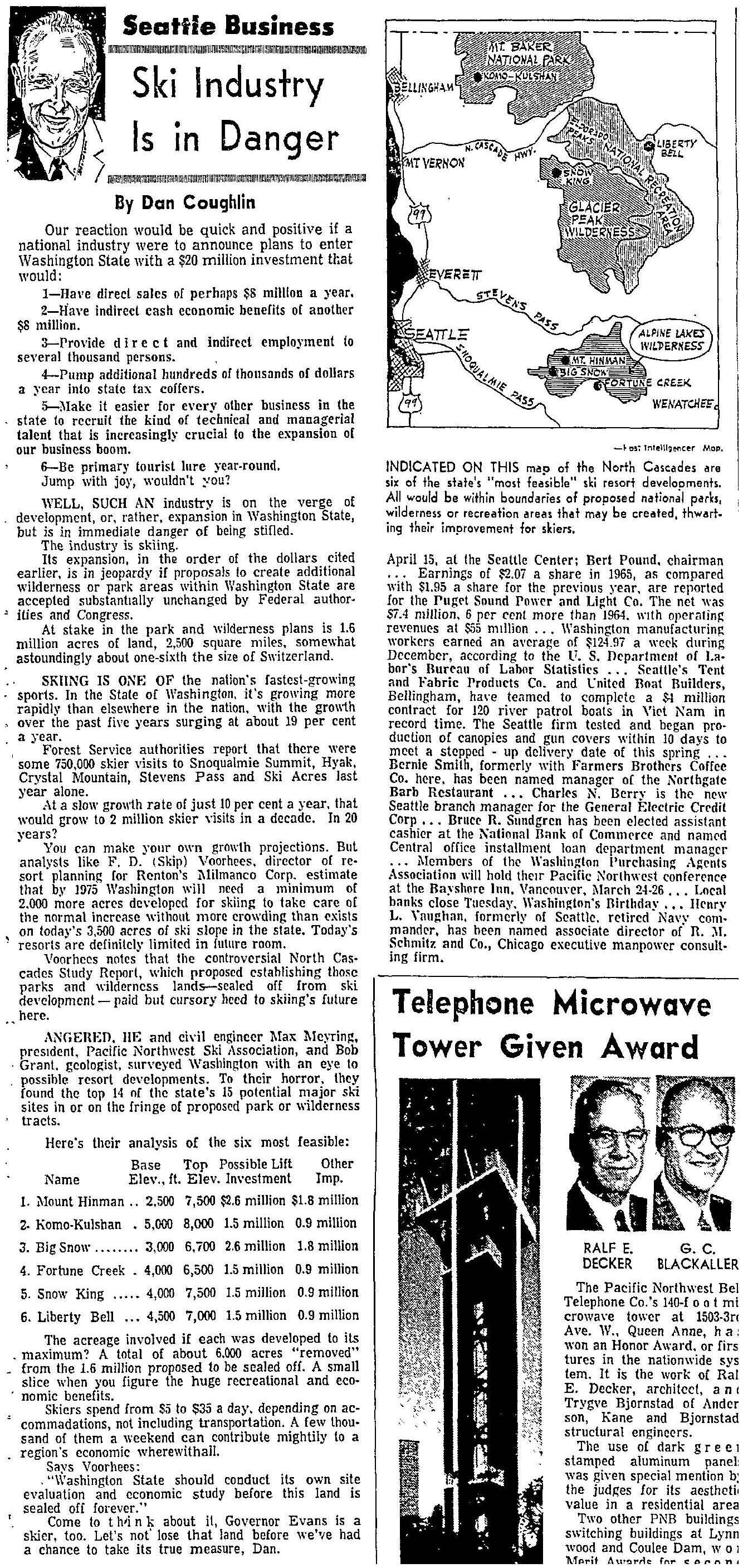
While I contend here that locations for additional ski terrain that don’t require wilderness area changes should be prioritized and preferred, it is nigh inevitable that some ski area expansion would realistically need to take place on wilderness area land. I know how difficult of a statement that is to make and it’s something that I only write after having poured over maps for months and finding no other viable option. It truly is the option of last resort.
It is worth, however, keeping the scale of this type of proposal in mind. Washington has 4,351,872 total acres of wilderness areas7. Let’s say we were to double the size of the six ski areas in the Washington Cascades, at roughly 800 acres for each that would be 0.1% of wilderness land. Put another way, let’s assume that our new ski area was to be even as large as the largest ski area in Washington, Crystal Mountain, at 2,600 acres. That would mean reclassifying 0.06% of Washington’s wilderness land. In other words, 99.94% of our wilderness land in Washington would continue to exist exactly as it does now. Meanwhile we greatly expand recreational opportunities for Washington and allow more of us to use and appreciate our mountains.
Even with such a small area developed, I would propose some additional considerations to limit the impact of that development:
- Any wilderness land removed is swapped with the same or more amount of land elsewhere to ensure that the overall amount of wilderness land remains the same or increases overall.
- Former wilderness land could be re-designated as a National Recreation Area ensuring that it remain used purely for recreational purposes and never for commercial resource extraction such as logging or mining.
- Only minimally necessary development is performed.
- There is a reason that I use the term “ski area” in my writing instead of “ski resort.” All of Washington’s ski areas are currently day use locations (Crystal and Mission Ridge are beginning to deviate from this). When the lifts stop for the day everyone goes home. There are no hotels, condo complexes, restaurants, shopping, etc. There is nothing “resort”-like about Washington’s ski areas. They are minimalist and simple and that’s just the way we like them.
- Massive Colorado-style resort developments that are glorified real estate sales should have no place in the Cascades. Which, since there is little private land in the Cascades, certainly not enough to build a large resort development, there’s little risk of this happening anyway.
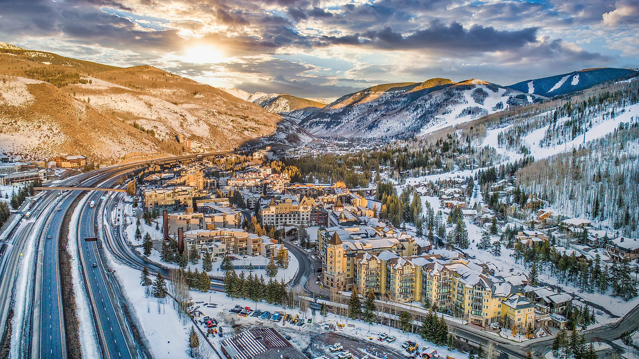 We don’t need to build cities in our mountains to provide access to them.
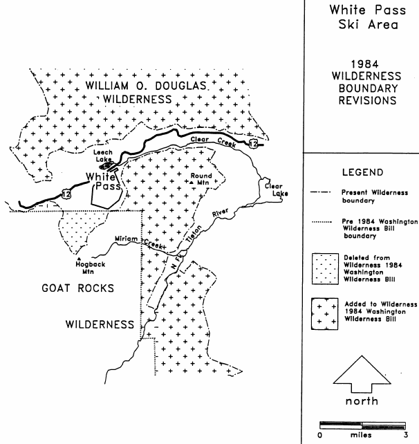
Furthermore, there is actually precedent for reclassifying wilderness for ski area development. In 1984 as part of the Washington State Wilderness Act some 800 acres of the Goat Rocks wilderness area were removed specifically to allow for White Pass to expand. This land became the Hogback/Paradise Basin expansion and effectively doubled the size of White Pass allowing for a much needed capacity increase. Representative Sid Morrison at the time wrote in regards to this provision in the bill:
An expanded White Pass area was truly the highest and best public use for that portion of the Goat Rocks [wilderness].8
This is indeed the metric we should be judging the use of these lands with, the highest and best public use. Plus, it helped that while the bill removed 800 acres from the Goat Rocks wilderness it added another 23,000 acres.
But this is public land. As a skier I am obviously somewhat biased in my assessment about what the highest and best public use is. This land belongs to all of us, not just skiers. As the 1964 Wilderness Act was created to preserve the character of undisturbed land for future generations we must make the argument that reclassifying land set aside for those purposes is in the best public interest for everyone, not just the limited few who want to use it for other purposes.
To that end, I would offer the following: These lands are protected by the 1964 Wilderness Act, a law that was created with the stoke of a pen. Land protections and the laws that establish them are not forever. The only thing preventing wilderness areas from all disappearing with another stroke of the pen is the ongoing political will to keep the Wilderness Act in place. That political will to keep them protected in turn comes from the public having a sense of appreciation for these lands and knowing why it is worthwhile to protect and preserve them. I know of no better way to instill this sense of appreciation for our mountains than to recreate in them and experience first hand the opportunities they present. Sufficient recreational access of all types, not just winter sports, is therefore necessary to protect our wilderness. Without that, the popular mentality can easily switch to “why should I care if some company wants to log those mountains I never go to?” Therefore, if limited development of 0.1% of this land helps to preserve the other 99.9% then I’d argue that is a fair tradeoff and in the highest and best public interest for everyone.
Are Skiers Ruining Our Wilderness?
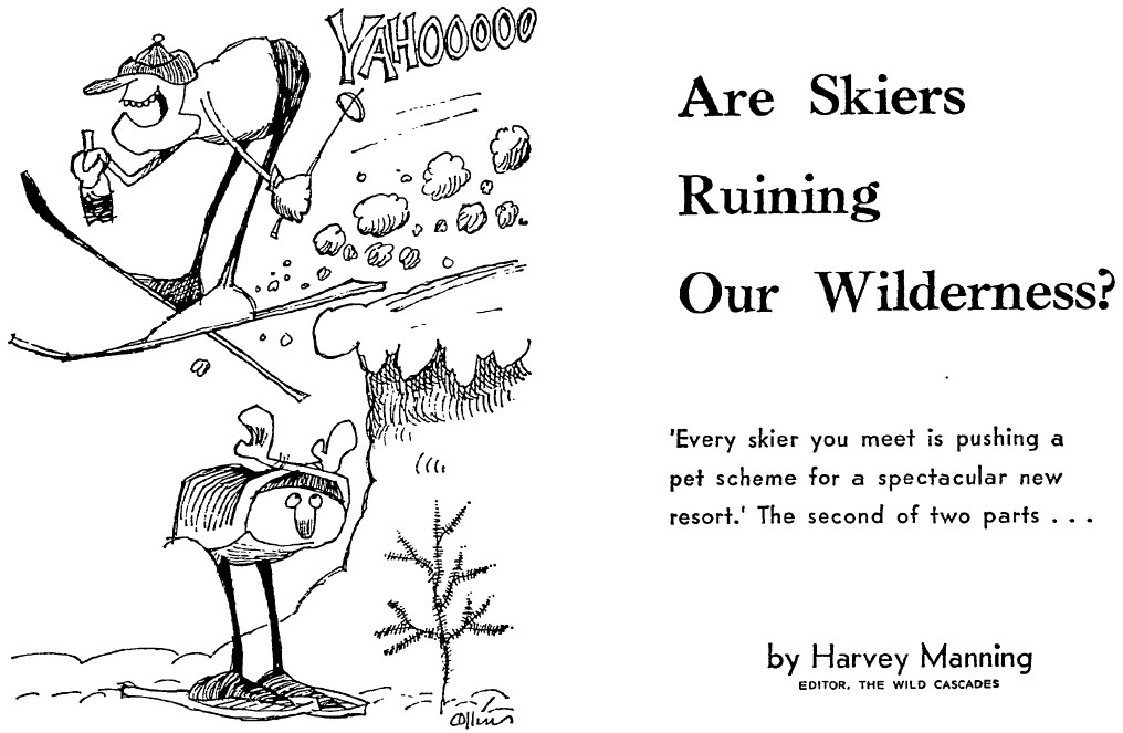
Out of the all of the research I did for this series of blog posts about the future of skiing in the PNW one article from 1967 seemed to be speaking out to me from across the decades. Written by Harvey Manning, chief editor of the first edition of the legendary book, Mountaineering: The Freedom of the Hills, he discusses the practical and not-so-practical ski area proposals made in the 1960s when our wilderness areas were first being formed and the politics that went along with them.
Right off the bat he writes:
Nowadays every skier you meet, and many a non-skier as well, is pushing a pet scheme for a spectacular new resort.
Which, as someone researching into a pet project to determine where a new ski area could go in the Cascades, gave me pause.
Given Manning’s legacy one may assume that his articles are about ski area development and wilderness preservation are incompatible with each other and no ski area development should take place. However, this is not the case. Instead, he discusses the ridiculousness of some proposals of the time, outlines some criteria that a serious proposal would need to follow, and gives credence to the idea that in the future it is likely that some wilderness land would need to be developed for recreational purposes. Overall, it was the most balanced opinion I had read regarding the development in the Cascades. Both of his articles are well worth your time to read through fully.
It is worth summarizing a few of the points he made here. As the editor of The Wild Cascades, a magazine published by the North Cascades Conservation Council (which is still published today), Manning noted “are the wilderness preservationists trying to lock skiers out of the mountain? The answer is NO.” and also “Now for the other question: Are the skiers trying to steal our wilderenss away? The answer to this is also a resounding NO” albeit one that required some qualification.
Manning shared the same concerns in 1967 that I do today. That population growth would require additional ski area development focused on local, day-use sites, but on an even larger scale than we would think of as practical today:
About every 5-10 years, I’d guess, we’ll need another Cascades [ski] area on the pattern of Crystal Mountain - maybe three to five or so between now and 2000. But let’s not get delusions of grandeur. These resorts will only be economic if they give us home folks good weekend skiing. Forget the fly-ins from Baltimore and Hong Kong. Remember the fly-outs to Alta and Aspen and by SST to Antarctica.
Flying supersonic to Antarctica for a week of skiing… the 1960s really were a wild time.
Manning expressed a distrust of the forest service throughout his articles. He noted that many of the anti-wilderness proponents were motivated by the desire to stave off land restrictions under the guise of recreational development so logging and paper companies such as Georgia-Pacific could continue to log the Cascades unfettered.
In asking that no land be “locked up” in national parks or national wilderness areas, that the status quo be maintained for 20 or more years until careful surveys of all potential ski terrain have been completed, they are asking for precisely what the Forest Service and its buddies want — log it all to hell and then fit in some picnic tables and tows among the stumps.
This is a fair fear to have given the amount of unrestricted logging of old growth forest happening at that point in time and is why I proposed above that any wilderness area changes should be made such that the land is reclassified as a national recreational area and explicitly forbids logging and other resource extraction except as strictly necessary for recreational facility development.
In his second article he gives brief assessments of some specific ski area proposals. The overarching theme for his commentary on these proposals being:

Meaning that there are certain areas of the Cascades which contain wilderness, some not protected at the time of his writing, that were too special and should remain in their untouched state, especially when considering developing them would yield only mediocre skiing. For example, no one here is proposing putting a chairlift up in the middle of the Enchantments.
Manning went on to discuss the possibility of how wilderness areas could be reassessed in the future given the needs and desires of future generations. With regards to the possibility of a Snowking Mountain proposal (more on this later, it’s one of the locations I discuss below), he wrote:
Snowking Mountain, south of the Cascade River, is tough. The skiing might be superb, and might be a year-round on neve, and despite the expense of access roads, and despite a drop of only 3,000ft is close enough to the people that investment might be practical someday. Balanced against these possible skiing values are incalculable important wilderness values — and protected values, since Snowking lies within the Glacier Peak Wilderness Area.
Preservationists would hate to lose Snowking, and never will give it up without much discussion. But preservationists who have toured there in winter on skis, and in summer on climbing boots, concede the balance of values might someday be pretty even. Not now, though, and not for a long, long time. […] In 1984 the interest in Snowking might be sufficient to consider removing the mountain from the Glacier Peak Wilderness Area.
It was interesting to read his take on the fluidity of wilderness areas. In 1967 the 1964 Wilderness Act was only passed a few years prior. It’s clear that there was still debate about how to think of the permanence of these lands. In response to the Alpine Lake proposals and the fluidity of these lands, Manning wrote:
As preservationists know to their sorrow, a wilderness area or a national park is never finally and absolutely created for once and all. What Congress does in 1967 it can undo in 1984 or 1999. The continuing battles of Olympic National Park, over the Grand Canyon, are examples that each generation has an opportunity to review and revise the public-lands decisions of its predecessors. But “locking up” wilderness does leave future generations genuine options, and that is why preservationists want a large Alpine Lakes Wilderness, even though it may include slopes that must later be deleted to allow mechanized skiing.
Not all of the suggested sites will be needed or wanted; between now and 2000 perhaps only a half dozen new alpine resorts, plus twice that many [ski areas], will satisfy the demand. Better let our children decide in 1980 or 2000 how much wilderness is enough, how much skiing room is required.
This all to say that we, the descendants of the generation that these lands were protected by, should consider making use of the options they afford. Is it selfish to use them and rob our descendants of those same options? I say no when considering we would be developing them for the same recreational use that our children would enjoy and that we are still passing down 99.9% of that land to our progeny. Is it time we undertook a once-in-a-generation review and revision of the land use decisions of our predecessors?
New Ski Area
Hopefully I’ve convinced you why we new more ski capacity, why we can’t rely on our existing ski areas to provide that capacity, what our snowpack is doing with climate change, and why we realistically need to consider some development of our wilderness areas.
Assuming so, now for the fun part: Let’s say we wanted to build a new ski area, where would be the best location for it, how would it get funded, and how would it operate?
Desired Characteristics
In one of my previous posts I summarized the findings of the 1970 North Cascades Winter Sports Study. 50 years on, I find its recommendations to still be apt. That is, the Cascades does not have the characteristics for large ski resorts. I know this is a hard pill to swallow, but its snow is too inconsistent, the winter weather often poor, high elevation terrain too difficult for the average skier, access difficult, and base area locations limited. This is not to say it’s impossible, but it does greatly limit options. Moreover, skiing in Washington will likely always be focused on day-use sites. For the reasons listed above, the Cascades are not suited to large destination ski resorts. Existing ski areas should remain focused on the local market. Any potential new ski area should be located near the existing population and be focused on serving it rather than trying to attract out of state visitors.
With those themes in mind we can outline the desired characteristics of a new ski area in the Cascades:
- The location would ideally be on the west side of the Cascades. This is for proximity to the Puget Sound population center and to reduce carbon emissions by needing to drive less miles and to stay within round-trip EV range.
- Being on the west side also reduces summer wildfire risk.
- The base area must be above 4,000ft at least in order to future-proof it from climate change.
- Ideally a base area above 5,000ft would be best. Snowmaking can compensate somewhat if lower but this is expensive and resource intensive and should be avoided if at all possible.
- It should have at least 1,500 - 2,000ft of vertical drop for skiing.
- As high of a summit elevation as possible is better, but it’s worth mentioning that terrain above treeline can be extremely difficult to ski on when visibility drops.
- It must be close to existing roads to avoid disturbing remote areas with new road construction and to control construction costs.
- Road access also needs to consider avalanche risk. Performing avalanche mitigation is costly.
- The traffic of existing road corridors should be considered as well. For example, anything along US-2 is going to suffer severe traffic problems until the highway is widened or towns bypassed.
- It should have a mix of beginner, intermediate, and advanced terrain. We don’t want mellow green runs everywhere and we also don’t want only cliff bands.
- A north facing aspect is generally preferred for ski area to avoid winter time southern sun exposure.
- A relatively flat area for a base area and parking is required.
- Easy access to the power grid is necessary for powering chairlifts instead of resorting to diesel engines/generators.
- Ideally not in a wilderness area. This would make it much, much easier since otherwise it would require an act of Congress to declassify wilderness land.
- For the sake of exploring options I do include some locations in wilderness areas here. Unfortunately, there are nearly no viable options in the western Cascades otherwise.
- Roadless areas would be nice to avoid as well, but there are literally zero potential locations to consider if looking outside roadless areas. Moreover, it’s still unclear if the current roadless areas permit ski area development or not. Hence I consider roadless areas fair game because otherwise the answer to all of this is “no new ski area ever.”
Limiting Environmental Impact
Any new development is going to raise environmental concerns. There are steps we can take to minimize these:
- Avoid sensitive areas entirely. There are some areas of the Cascades that are exceptionally beautiful and absolutely no one wants to see developed. This is also inline with the idea that we should not be losing our first rate wilderness for second rate skiing.
- For example, Washington Pass, Cascade Pass, Alpine Lakes Wilderness, the Enchantments, and many more should not be considered regardless of their positive characteristics for skiing. While some of these areas meet many of the desired characteristics outlined above I have not considered them due to the horror of considering to develop them.
- Tree loss should be minimized. While it is unavoidable to remove some trees for parking lots, chairlifts, and base area infrastructure, it can be minimized. For example:
- Utilize naturally tree-less areas as much as possible (scree fields and meadows)
- Prefer thinning trees vs. clear cutting
- For ski runs that do need to be cut prefer them as narrow as practical. It may also be possible to put them near the edges of the ski area to double as fire breaks for wildfire protection in the summer.
- Disallow cutting of old growth trees over, say, 80-100 years old. These trees are important habitats and fare much better in wildfires than new growth trees so we’d like to keep them around as much as possible.
- As discussed previously, it may be possible to build a parking garage to minimize the footprint needed for parking lots. Or at least start with a parking lot with the intention of building up rather than out as necessary over the years when demand requires.
- Consider replanting a tree elsewhere/nearby for every tree that is removed.
- Only electric chairlifts should be used.
- The ski area should be high enough elevation that ideally no snow making is required. This saves money and resources on water and electricity for producing artificial snow as well as land for building reservoirs to draw water from.
- Limit base area development to the bare minimum. This would entail a small lodge for lessons, rentals, tickets, ski patrol, restrooms, lunch, and warming. Plus a maintenance and operations facility and some employee housing. No on-site hotels, condos, chalets, or luxury lodges with spas, restaurants, and shopping.
- Consider the use of hydrogen powered snowcats.
- Snowcats/groomers are potentially a good application for hydrogen fuel in that they operate in a fixed location so one refueling station is all that is needed and having a more limited range is okay since a quick trip down the mountain to re-fuel is not a big deal. It would, however, require a source of renewable hydrogen since most hydrogen production currently comes from fossil fuels.
- There are also some electric options too. Either hydrogen or electric still has some ways to go before ready for commercial use but it’s reasonable to assume that the timeline it would take to build a new ski area would match up with the commercial availability of these types of snow groomers.
- Electric snowmobiles should be used by ski patrol and operations. The limited range is not a concern when operating in a fixed area and can be charged when not in use during the day.
- Support EV charging in parking lots.
- This may be difficult to support on a large scale in conjunction with snow removal, but that is not an insurmountable issue.
- If possible, consider having the parking lots or entire base area be separate from the ski area. For example, consider Silver Mountain Idaho where the parking lot is in town and the longest gondola in the US transports skiers up the mountain to the ski area. This is highly location dependent but could offer a model that avoids most land disturbance related to parking and base area development.
- Construction of new chairlifts could be done in the spring as needed when sufficient snowpack does not require the building of roads to access construction sites. For example, how the Coulior Express at White Pass was built.
If all of these items are enacted it would limit the environmental impact of the initial development plus reduce the carbon emissions of ongoing operations of the ski area to only cars driving up. Which, in time, will hopefully become electric as well. Washington has an opportunity through new development to set an example for how to decarbonize a currently carbon intensive industry.
Areas Not Considered
There are some areas that I did not consider for a multitude of reasons.
First, I did not consider locations on the east slopes of the Cascades for two reasons:
- These locations are too far from the Western Washington population to be useful as day-sites.
- The eastern side of the Cascades is more prone to wildfires than the western side.
Second, the Stampede Gap area, from near I-90 to just north of Crystal Mountain is a notably low elevation section of the Cascades not suitable for ski areas. Third, south of Rainier/White Pass is starting get closer to Portland than Seattle and also on the edge of what is useful as a day-site. I also gave limited consideration to the Stevens Pass corridor. Some locations were considered here but until the highway is widened I find it difficult to consider sending more traffic up the Skykomish Valley when there are other less developed areas to disperse crowds throughout.
Thus, my primary area of focus is the area north of Stevens Pass and into the North Cascades. This is due to its higher elevations, existing road access, and being undeveloped for skiing aside from Mt. Baker ski area. Admittedly, it also the part of the Cascades I know the best and spend most of my time in so there is some bias here.
Mapping the Cascades
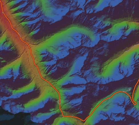
In order to make it quicker to identify and assess location candidates I created a map that shades the Cascades by our elevations of interest. It also has layers for National Forests, wilderness areas, and roadless areas. There is also a forest roads layer to assess if a location has a (semi-)developed road leading it already. Moreover, to get a sense of the run difficulty of skiing at the location a slope angle layer was created.
This map was created from USGS DEM data9 for the Cascades, imported into QGIS, converted to hillshade & slope angle perspectives, colored by elevation band, and then exported to raster tiles for display as a web map. Note that the lighting here is coming from the north which is unnatural, especially in the winter, but provides the most “normal” looking map. I also created a layer with the light coming from the south to get a sense of which aspects would be shaded in the winter but I found it made little difference when looking for locations so it has been omitted here to save on bandwidth.
The elevation colors correspond to the following:
- Brown: < 3,500ft (nonviable today)
- Red: 3,500ft - 4,000ft (likely nonviable in the future)
- Orange: 4,000ft - 5,000ft (acceptable)
- Green: 5,000ft - 6,000ft (good)
- Blue: > 6,000ft (ideal)
It is worth noting that these elevation bands are a generalization. The warmer air on the western Cascades necessitates higher elevations than the colder air on the eastern Cascades. They also don’t account for local weather effects such as cold, eastern WA air making its way up Snoqualmie Pass. As the focus is on skiing in the western Cascades appropriate elevations were chosen for that region.
For the slope angles, the colors correspond to:
- Brown: 0-5°
- Green: 5-15°
- Blue: 15-25°
- Orange: 25-55°
- Red: >55°
These correspond with slope trail ratings (beginner, intermediate, advanced/expert). Anything over 55° is considered unskiable. This layer is used to check slope angles for anything too steep or too mellow for desired ski area terrain difficulty distribution.
So, here’s the map with the areas I’ve given consideration to for both the purposes of mechanized ski areas and backcountry access points:
Potential Locations
Finally, let’s take a look at specific proposals. First though, a note: There is no single location that I have been able to point to and definitely say “this is it.” Some are close to that, but the sad truth is that there are no ideal locations for a new ski area in Western Washington. All of the locations below have pros and cons. Their viability depends on what characteristics you value the most. As the 1970 North Cascades Winter Sports Study noted:
Numerous hours were spent observing the study area from fixed-wing aircraft, helicopters, and ground vantage points. Some good potential sites, however, may still be undiscovered. Also, in the decades to come, the physical limitations or human desire for winter fun will undoubtedly change drastically. Therefore, what today is not feasible, may tomorrow be, and vice versa.
Thus, this is not meant to be an exhaustive list of possible locations or even that these are all viable in the first place. Certainly other locations exist and I encourage anyone with suggestions to share them with me please!
Let’s take the tour.
Mt. Baker NRA
Note: Mt. Baker here refers to the actual Mt. Baker rather than the existing ski area.
One of the environmental considerations outlined above was to avoid sensitive and unique areas in particular. Given that Washington has thousands of named mountains but only five volcanoes, it is reasonable to treat our volcanoes as unique and special areas. Thus, Mt. Baker is assessed here with hesitation and for one reason only: our current laws ironically make it easier to use Mt. Baker for motorized recreational purposes than many fairly generic areas of the Cascades. It is not without precedent to consider a volcano for skiing though; consider Mt. Hood and Mt. Bachelor in Oregon, for example.
Why is this though? The Washington State Wilderness Act of 1984 created a tremendous amount of wilderness areas in the Cascades, including on and around Mt. Baker. Except for one particular carve out: the Mt. Baker National Recreation Area. This area (pictured below) is a wedge shape extending nearly to the summit of Mt. Baker along its south face. The act explicitly allows for snowmobile use in this area in addition to other recreational uses as such:
The Secretary shall administer the recreation area in accordance with the laws, rules and regulations applicable to the national forests in such manner as will best provide for (1) public outdoor recreation (including but not limited to snowmobile use); (2) conservation of scenic, natural, historic, and other values contributing to public enjoyment; and (3) such management, utilization, and disposal of natural resources on federally owned lands within the recreation area which are compatible with and which do not significantly impair the purposes for which the recreation area is established.
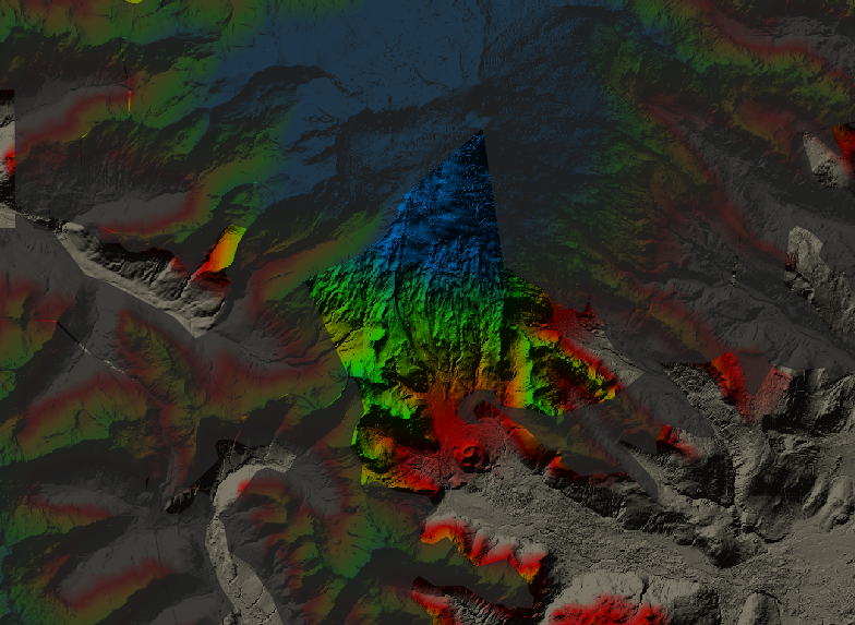
So while nearly all of the high elevation terrain in the western side of the Cascades is designated as wilderness, a decent amount of Mt. Baker is not and is specifically “zoned” per se for motorized recreational use. In terms of what is politically possible, the best chance for a high elevation ski area in western Washington would need to be outside of a wilderness area and the Mt. Baker NRA is just that. As much I would prefer to not develop one of our precious few volcanoes, this is what the laws have left the door open to.
With that in mind, let’s look at some of its other characteristics:
- Good road access exists to the Easton Glacier parking lot. Some of this road is already maintained in the winter for access to the sno-park. It would need to be widened and paved, however.
- Its base elevation would live around 4,000ft and the summit is limited by the edge of the Easton Glacier around 6,000ft unless a way was found to build a lift higher.
- The base area would be a mere 7 miles from Upper Baker Dam allowing for easy electrical connections to power chairlifts.
- Its location on the edge of the Cascades makes for a ~2 hour drive from downtown Seattle. Plus, most of that is I-5 and Rt 20 so (on weekends) traffic would be considerably less than roads such as Stevens Pass.
- If necessary, Baker Lake provides for an ample reservoir for snowmaking. This water being less needed in the winter than in the summer.
- Its proximity to the town of Concrete would spur economic development there. It also allows for ample private land relatively close to the ski area for development of housing.
- If needed, Schriebers Meadow provides a great deal of fairly flat land for base area development and/or parking. It’s close proximity to what would be the ski lifts would allow for a remote parking situation where a tram or gondola could transport skiers up to the mountain requiring less cutting of trees and grading involved in building parking lots higher up the mountain.
- The lifts could also see use in the summer for those wishing to hike in the area, summit Mt. Baker, or ski tour on the glacier in the summer.
It’s worth noting as well that this would displace or partially displace snowmobilers that currently use this land for that purpose. Displacing someone from their present activities is not something to be taken lightly. Thus it should be determined if skiing and snowmobiling can coexist at this location. If not, a suitable replacement location should be established. It is easier to find land for snowmobiling than it is for a ski area, after all.
To help visualize these potential locations, I took advantage of a clear day to take aerial photos of some of them before the snow began melting this past spring. These photos were all taken on April 24th, 2022. To get an idea of the snow levels, this is something of a springtime snowpack. April 2022 was exceptionally snowy and thus the snowpack this month more closely represented normal March snowpack than late April.
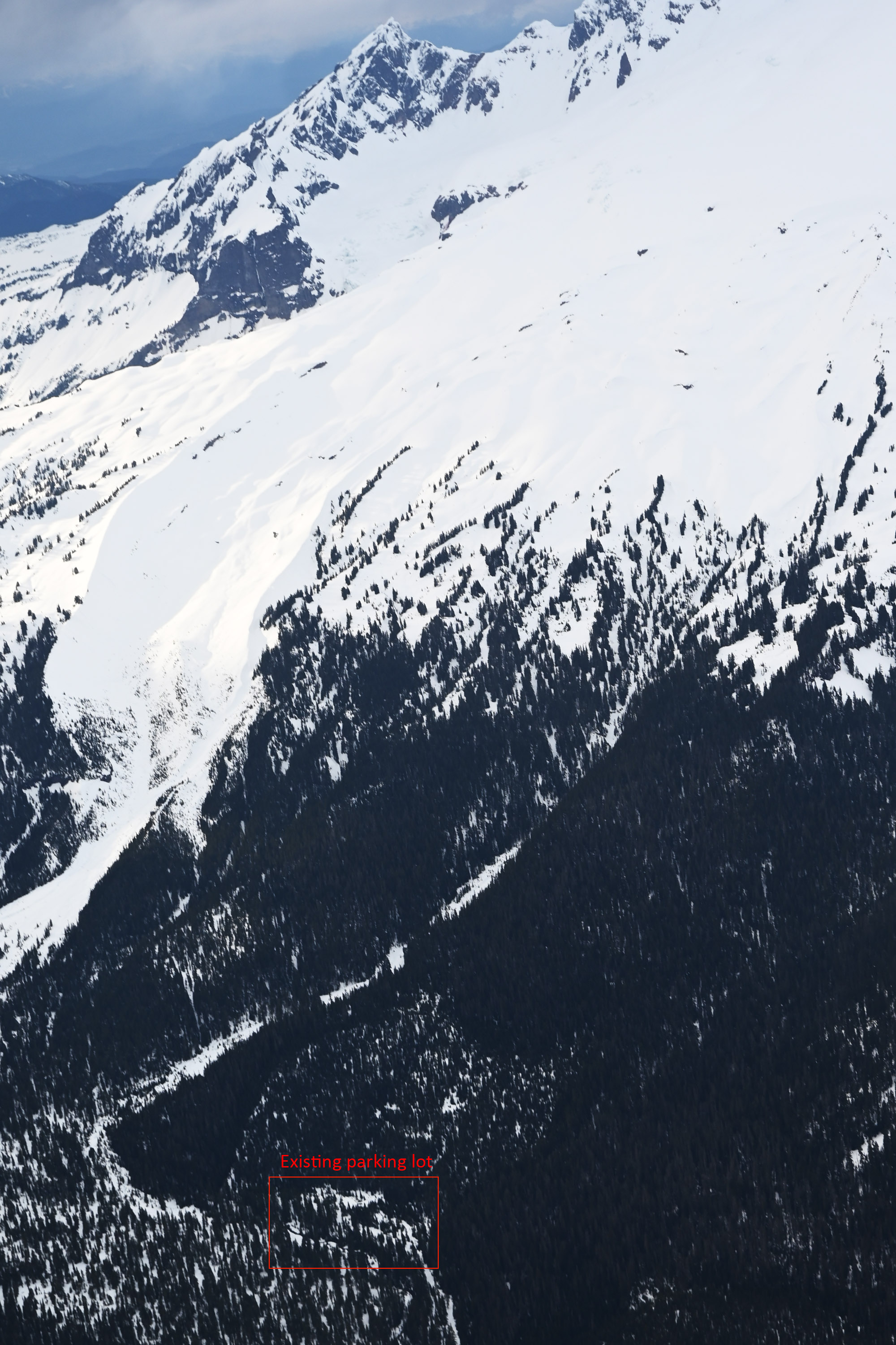
Cutthroat Pass
Cutthroat Pass is one of the locations studied in the North Cascades Winter Sports Study. Located near Washington Pass along the North Cascades Highway, its most attractive quality is that it provides a huge amount of high elevation terrain, even for its would-be base area. Additionally, it is not located within a wilderness area and it has excellent road access by merit of being along the North Cascades Highway.
The downsides to it being that it’s fairly far from Seattle at over three hours. This would mean its primary demographic would be Whatcom, Skagit, and Snohomish county residents. That still represents a good (and ever growing) amount of people, certainly enough to support a small ski area. Its remote location means electricity would be a problem, however.
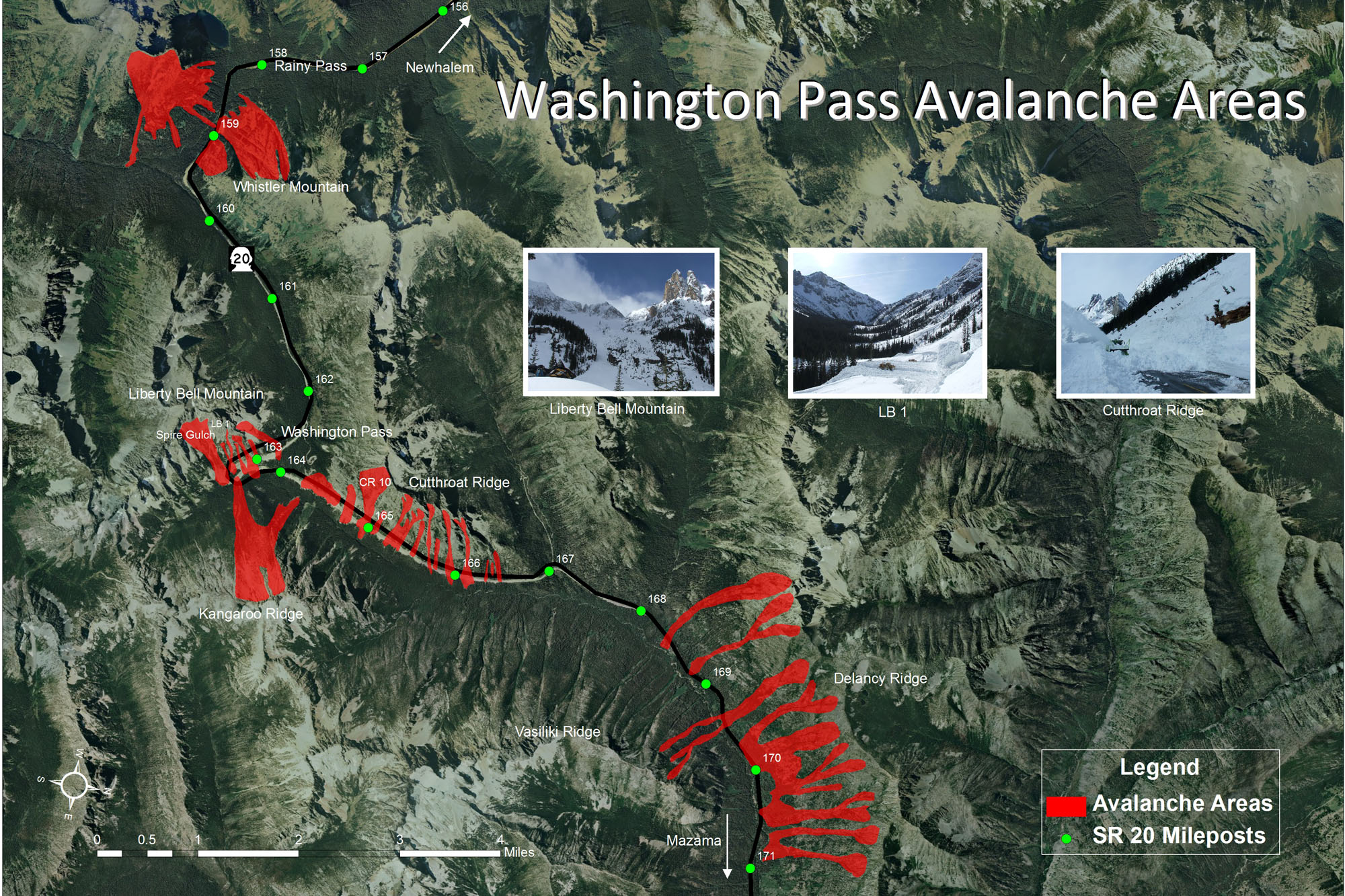
The biggest issue, though, is that the North Cascades Highway is closed during the winter due to avalanche danger. The question for this location and any others along Rt. 20 becomes is it possible to keep the North Cascades Highway open during the winter? Possibly! At least to Rainy Pass, where our base area would sit. We need a small history lesson to understand why this may be though.
When the road was being built in the 1960s the state did not plan to initially maintain winter access but rather wait until usage and traffic deemed it necessary to undergo the expensive process of maintaining winter access, ideally without the need for any snowsheds.10 In the early 1970s WSDOT hired Ed LaChapelle, one of the pioneers of the field of avalanche forecasting, to conduct a study of avalanche activity along the North Cascades Highway. The state found it so useful that they hired LaChapelle to conduct similar studies elsewhere in Washington. In the years that followed, his team went on to conduct these studies and install remote weather stations in the passes and ski areas and develop a systemic method for avalanche hazard forecasting. In 1979 three members of the team, Mark Moore, Rich Mariott, and Roland Emetaz became the founding members of NWAC.11
The study that LaChapelle completed resulted in two publications: Avalanches on the North Cascades Highway and North Cascades Highway SR-20 Avalanche Atlas. The former outlines his findings and recommendations. In the study, LaChapelle noted that the most dangerous sections of the road are the Washington Pass and Cutthroat Ridge (as opposed to Cutthroat Pass) areas. He noted it may be possible to keep the road open during the winter but with regular closures anywhere from 10-40% of the time depending on risk tolerance, avalanche danger, and amount of artillery-based avalanche control conducted. Another option would be to maintain the lower elevation sections only such that less time would be needed to clear the high elevation sections in the spring. He also considered the possibility of snowsheds or other defensive structures. It was noted that these could certainly help with keeping the road open more often but their cost and effect on the scenery of the area made them unlikely options to move forward with. Ultimately, the state used LaChapelle’s findings to argue for the road to be closed entirely during the winter.12
Credit: WSDOT
What does this mean for a location like Cutthroat Pass? Well, the good news is that it’s west of the primary areas of concern: Washington Pass & Cutthroat Ridge and it would seemingly be reasonable to keep the road open to this location given a similar avalanche control program on the order of magnitude as Stevens Pass. However, this would be extremely expensive. The North Cascades Winter Sports Study estimated it would cost $650k/yr to keep the whole road open.10 Adjusted for inflation that’s $4.9M/yr. Compare that to the $200-250k/yr spent to clear the road each spring.13 That’s a tough sell for a road that would only access a small ski area. Only Rt. 542 to Mt. Baker is kept open in the winter for purely recreational purposes. All other passes in Washington are for connecting the east and west of the state throughout the winter. Basically, it’s an issue of funding to keep the road open. As of now, there is no demand for a partial clearing of the road hence it is not done. It would seem that given the funding and demand to do so, which a ski area may create, it could reasonably be kept open through the areas of interest.
Ultimately, the Rainy Pass area of the North Cascades likely has some of the most ideal terrain for a ski area in Washington: abundant high elevation terrain with excellent road access that is not in a wilderness area. However, its remote location puts it borderline too far from the western Washington population and uneconomical for maintaining winter access to.
Snowking Mountain
Snowking Mountain may be my favorite potential location all things considered. The elephant in its room is that it is located entirely within a wilderness area so we need to put that aside when considering its other qualities.
Snowking is located just south of Marblemount and is accessible from multiple sides. Either from east on the Cascade River Road side or from the west where Illabot Creek Road comes within 2-3 miles of the base of the mountain. The mountain itself has a summit of 7,433ft and a myriad of bowls of various aspects. Electricity connections may be a problem, but the nearest power lines appear to be roughly 10 miles away so it’s not nearly as remote as other potential locations.
Additionally, it’s proximity to Marblemount means it is roughly a 1.75hr drive from Seattle. It could also provide a healthy amount of economic development for Marblemount and make it into something of a ski town in the winter. As the North Cascades Hwy is closed during the winter it would also mean minimal traffic for getting to/from the ski area on the underutilized winter-time roads there.
Snowking-Found Creek was one of the locations studied in the North Cascades Winter Sports Study (NCWSS) which came to the conclusion to eliminate it as an option. So why is it one of my favorite locations? Because the NCWSS considered one specific part of Snowking only. Also in 1970, prior to the 1984 WA State Wilderness Act the authors of the study had vastly more land to consider as potential locations which comparatively did not make Snowking look all that attractive. They also weren’t specifically looking for a location close to the Seattle population center. When you consider that today we have far fewer options due to laws enacted between then and now some of these previously eliminated options begin to look attractive again.
The Snowking-Found Creek site may be a poor location (and it certainly does from looking at aerial photos) but other parts of Snowking look entirely reasonable; it’s huge area after all. When you combine it with Mt. Chaval or Mt. Buckindy next door, there’s even more options. In fact, it’s hard for me to pin down one specific location in this general area because there are a plethora of possible options. None perfect mind you, but many promising.
If some wilderness land were to be re-classified to allow for development, Snowking would prove a good candidate in that it is located on the edge of a wilderness area. Development of it would not mean cutting deep into wilderness land but rather developing land that is currently on the edge of it thus limiting impact.
Hidden Lake
On the other side of the valley from Snowking Mountain sits Hidden Lake Peak. Admittedly, Hidden Lake is something of a long shot. But it’s currently a popular backcountry ski location and not in a wilderness area so I wanted to cover it briefly.
Hidden Lake is interesting in that it’s of fairly high elevation (7,000ft), located off of Cascade River Road, and not in a wilderness area. The North Cascades National Park starts on the other side of the ridge but the west side of Hidden Lake Peak is all National Forest land.
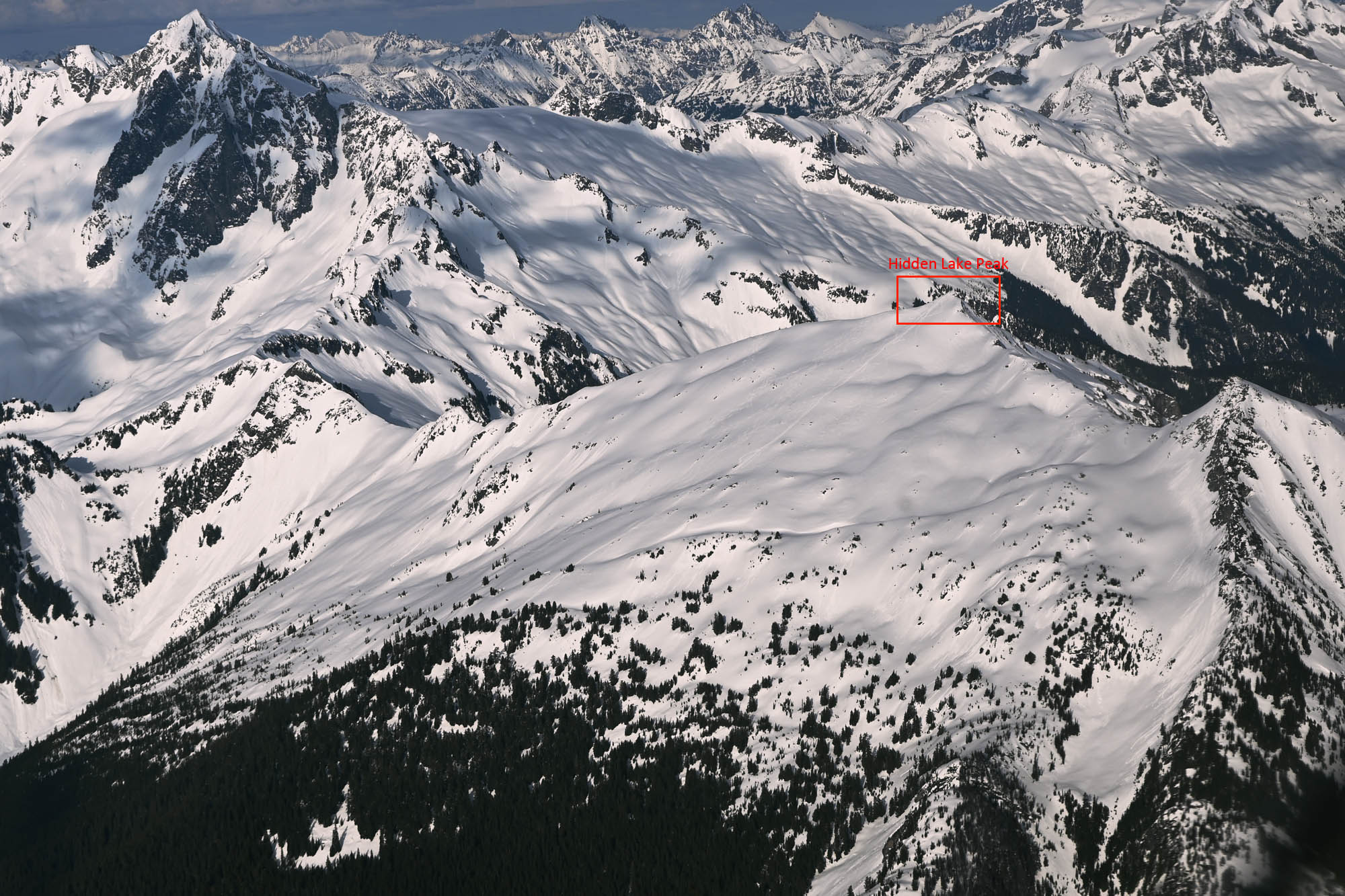
The primary benefit to Hidden Lake is its location. Located outside of Marblemount it’s easily accessible, Cascade River Road is paved most of the way there, and it would not be too much trouble to run electricity a few more miles up the road.
The primary problem with Hidden Lake, however, is lack of available land for a base area. The only reasonably flat land is along Cascade River Road. This would necessitate some type of transfer system to get skiers up to the snow level. The secondary problem is that the size of the mountain simply isn’t that large. Assuming the land outside of the park is only on the table, then it’s really just the west face of the mountain which could be served entirely by a single chairlift.
It’s for those reasons that Hidden Lake does not have the terrain characteristics for even a small ski area.
…however, it does have potential as a sort of limited access ski area similar to Silverton Mountain, Colorado. Silverton operates an ultra-minimalist ski area with a single chairlift and a base area comprised of a yurt and small parking lot. For most of the winter it is open to guided trips only with typically fewer than 80 skiers on the mountain. Some avalanche mitigation is done but all skiers are required to have an avalanche kit with them to be on the mountain. Something similar could work at Hidden Lake, especially if the lift was used to gain the ridge and then those wishing to ski tour in the park would have easy access to the high elevation terrain and excellent winter skiing there.
White Chuck Mountain
White Chuck Mountain is something of an unconventional option and a long shot in general. It’s not especially large but it is not located in a wilderness area, is close to the town of Darrington, and has road access to a would-be base area. While its summit is just shy of 7,000ft, what could be the ski area would sit more between 4,500ft and 6,000ft. Not necessarily ideal, but still workable.
In addition to road access, it has a good amount of flat land for a base area and parking. And similar to Marblemount, the proximity to Darrington could spur economic development there while providing nearby private land for housing.
Sloan & Bedal Peaks
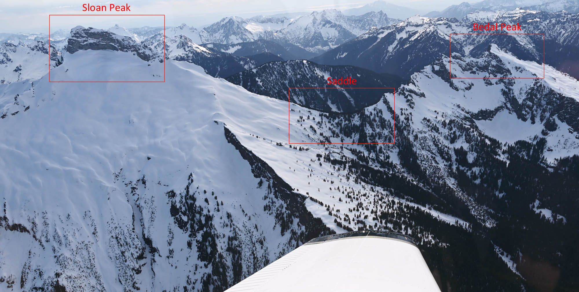
Sloan Peak and Bedal Peak are similar to White Chuck Mountain in that they’re not particularly ideal locations but they do have a fairly highly summit of nearly 8,000ft, have existing road access, and are located near Darrington. If Mountain Loop Highway were paved and maintained in the winter, this area could be 1.5-2 hours from Seattle. It is, however, in a wilderness area.
The terrain here can possibly work nicely as Sloan and Bedal Peaks are connected by a high elevation saddle which could make for good mix of ski area terrain.
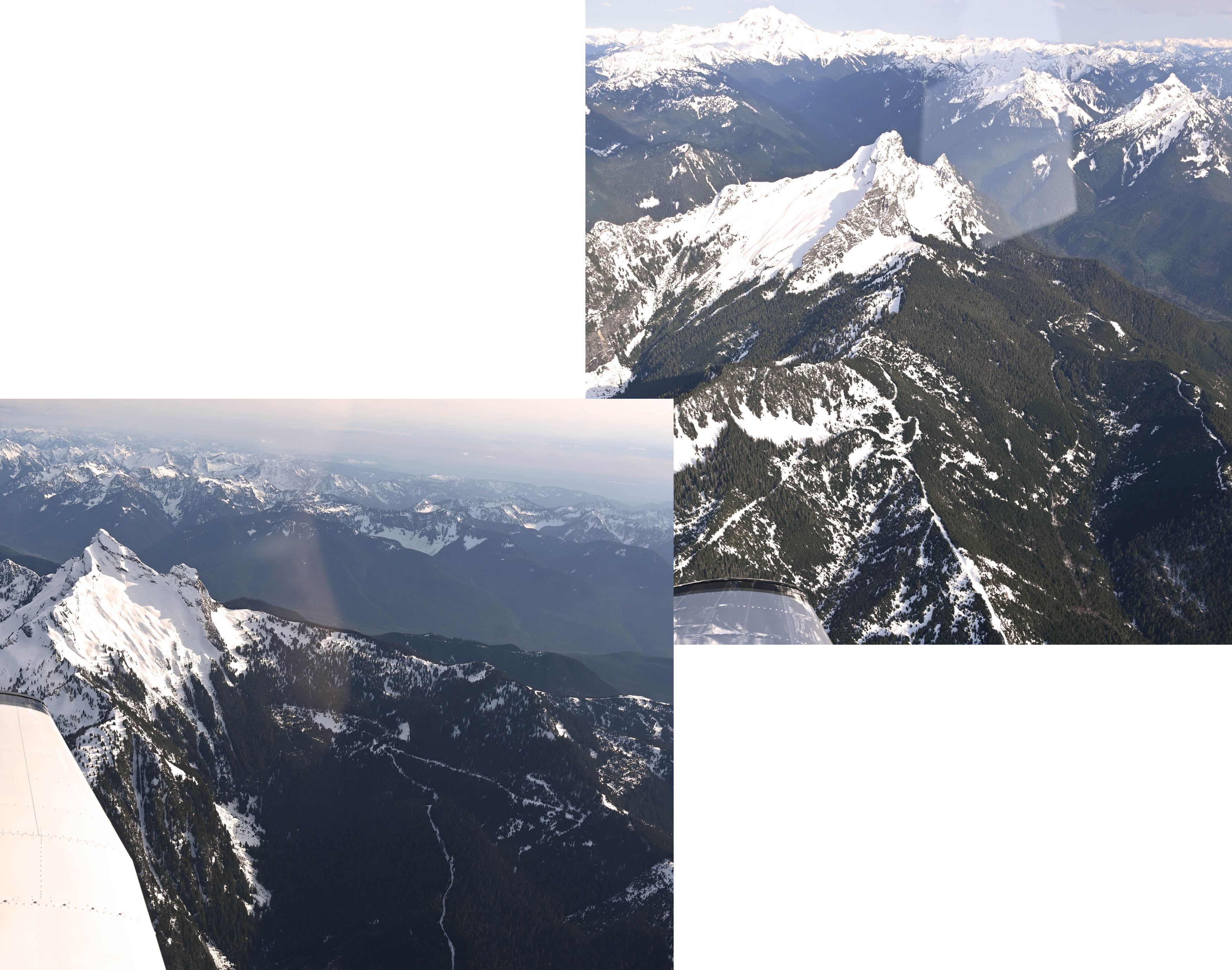
Mt. Howard, Mt. Mastiff, and Rock Mountain
A bit down the road from the Stevens Pass Nordic Center sits Mt. However, Mt. Mastiff, and Rock Mountain. These three mountains are all fairly high elevation, at around 7,000ft. They also have the benefit of sitting next to US-2 thus providing existing winter maintained road access and easy electricity access. Moreover, they are not in a wilderness area.
The downside here is that the elevation at the road is well below the typical snow level at ~2,700ft. While all this flat land would be great for parking and a base area, it would mean that a gondola would be needed to get skiers up to the mountain and back down again at the end of the day. That’s certainly do-able and could be seen as a benefit as it limits impact to the higher elevation environments. As with all gondolas though, it is extremely expensive and likely outside the realm of possibility for a small ski area.
Plus, being another 15 minutes down the road from Stevens would add another 30 minutes round trip which is starting to be a stretch when combined with the existing travel times due to traffic on US-2 in the afternoons.
Yodelin
Assessing Yodelin requires a bit of background information first.
The Yodelin ski area sat a mere 1.5mi down the road from Stevens Pass and operated from 1969 - 1974. Unlike most ski areas in Washington, it was planned with residential housing in mind. Plans called for four chairlifts in addition to a cable car to Lichtenburg mountain on the north side of the highway.14
Unfortunately, a negligent developer of these residential sites ignored avalanche warnings and in 1971 an avalanche killed four people in two cabins.15 The ski area, on the other side of the highway, continued to operate, even adding a second chairlift the following year. However, by 1974 economic issues forced its closure taking with it the possibility of expanded skiing along US-2.14
Today Yodelin is a popular beginner ski touring location. Its ski runs are still well defined and visible if you know where to look from the chairlifts at Stevens. In addition, its parking lot continues to be used as an overflow lot for Stevens on busy days. The residential cabins on the north side of the highway remain as well.
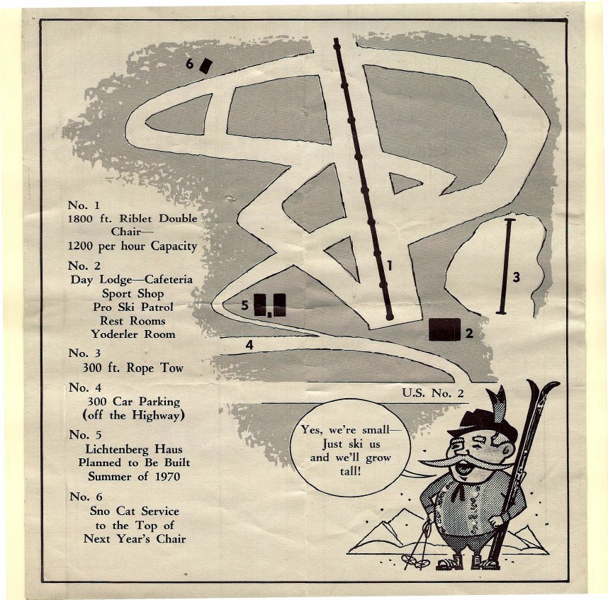 1969 Yodelin trail map, credit skimap.org
While Yodelin’s terrain is not all that exciting and it has the problem of being right next door to Stevens Pass meaning the parking woes would continue, it does have some positive characteristics:
- It is a former ski area and it is far easier to re-open a closed ski area than to develop a brand new site.
- Runs were previously cut so any re-clearing would be only new growth trees. In fact, from satellite photos it’s clear that most of this land has been logged previously.
- It is not in a wilderness or a roadless area.
- In terms of providing competition to Stevens and giving skiers a choice of where to ski, having another option right next door couldn’t be better.
- It closed primarily due to competition with the larger Stevens Pass. Given how overcapacity Stevens presently is, it would be hard to imagine a ski area less than five minutes further down the road being underutilized.
On the other hand, having a ski area right beside one of Vail’s properties would likely be fought tooth and nail by the corporation. It also adds even more traffic to US-2. Plus, given that Stevens currently uses the old Yodelin parking lot as an overflow lot I’d assume they have some type of right to use that land. Any base area for a new Yodelin would likely need to build a new parking lot and base area.
Operation & Economics
Assuming that a suitable location was found for our ski area, there is the all important issue of funding initial development and how such a ski area would operate. It may seem like an exceptionally daunting task to start a ski area, and it should be as it’s no small undertaking. However, consider that many, if not most, ski areas have humble beginnings. They were usually no more than a small group of people that started with a single chairlift and grew from there as the sport grew. Let’s consider a few examples from Washington in particular:
The history of Crystal Mountain is deep and rich but to summarize it here, shortly after World War II and with the demise of the tow rope at Paradise, interest grew for a ski area outside of Mt. Rainier National Park. A small group of local skiers and businessmen spent a few years searching for the right location before landing on the Silver Creek area. In 1958, they then formed Crystal Mountain, Inc. issued a stock offering to raise the funds needed for the initial development of the site. Investors were given an annual dividend of one lift ticket per share having bought at least 20 shares at $50/share; roughly equal to $10,000 in total today. 800 investors took up the offer. In 1962 Crystal Mountain opened with two chairlifts and a third, Green Valley, built the following year.16 When Crystal Mountain, Inc. was sold to Boyne Resorts in 1997 the shareholders converted their holdings into membership units in the Crystal Mountain Founders Club which continues to operate today.
A similar story played out for the founding of Mission Ridge. In 1959 Wilmer Hampton, Walt Hampton, Magnus Bakke, and others raised $1 million through selling stock in the to-be Mission Ridge. In 1966 it opened with two chairlifts.17
What we can learn from this is that there is a history of successfully selling stock in the corporation behind the ski area in order to raise money to fund its initial development. Assuming the 800 investors of Crystal bought the minimum $10,000 that would be $8M in startup money. These days I can only imagine that interest would be far greater. Plus, when considering these shares came with lift tickets, a $10,000 investment could be seen as a bargain considering what season passes cost at most ski areas these days.
This is not to say that a new ski area should adopt all of the practices of the past. The creation of another for-profit ski area operating on national forest land would not serve the interests of the public at large. If an entity is to be formed to operate a new ski area it should be created as a non-profit and/or co-op. The non-profit would help ensure that prices remain reasonable and accessible while the co-op would ensure the best interests of local skiers are kept front and center. There are some examples we can look to to see how this would work.
Bridger Bowl, Montana
Bridger Bowl in Montana operates as a non-profit. It is governed by the Bridger Bowl Association which has an elected board of nine volunteer directors. The association in turn has biannual association meetings, monthly board meetings, and separate committees all in the interest of addressing concerns about the ski area and to promote the sport of skiing in Montana. Membership is open to any Montana resident 18+ years old with $10/year annual dues.18 Compare this to the ski corporations that run our mountains in Washington who operate behind closed doors with little to no community engagement and serving only their shareholder’s interests of increased profits year over year.
Skeetawk, Alaska
Skeetawk is of particular interest having just opened in 2020 and being a volunteer and community driven project to raise the money needed to form the non-profit ski area. Skeetawk currently operates as an ultra-minimalist ski area with just a small yurt, parking lot, and one chairlift. Even more impressive is that the organization was formed in 2015 and was able to open a new ski area in only five years!19 They have plans to continue to expand the area by opening a second, high speed quad to the tune of $10M which will greatly expand their vertical drop and terrain.20
How was this done? Through community engagement, effective fund raising, and many volunteers working together to build a non-profit ski area that worked for them. In addition to the usual revenue streams of selling day tickets and season passes, Skeetawk raised money through sponsorships of chairlift chairs and trails. For example, for $100,000 a local company’s logo would be placed on a tower on the chairlift. Or for $25,000 you could choose the name of a ski trail.
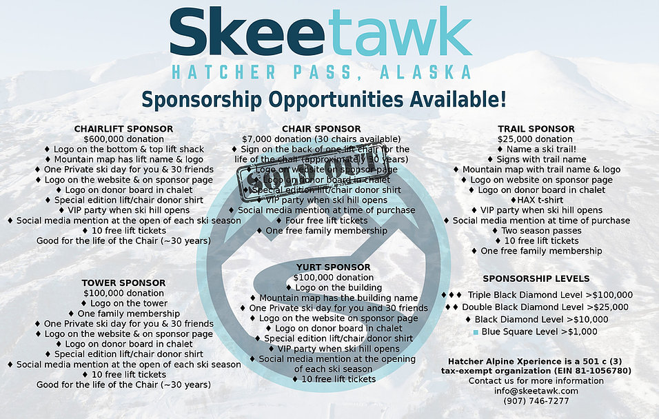
These examples demonstrate how a community driven approach to get funding for a new ski area in Washington would be entirely feasible. It’s difficult to put a dollar sign on a target amount given all of the variables involved, but let’s use Skeetawk’s $10 million figure for installing a high speed quad as a reference point. Through a combination of stock sales and corporate sponsorships along with volunteers to help build all of it, an avenue for the founding of a small ski area becomes visible. With an average funding on $10,000 per person/business (the same inflation-adjusted amount Crystal was founded with) that would mean only 1,000 people would need to be involved. Given the population of Western Washington and how passionate skiers are around here that number would seemingly be easy to hit and with corporate sponsorship it could likely be much higher.
Whistler vs. Blackcomb
Let’s say a small ski area got built, how would it compete with the well established ski areas? Well, for one our ski areas are so ridiculously overcapacity that any ski area would easily have more than enough customers to fill its capacity. There is, however, an example to consider here. In 1980 Blackcomb in BC opened right next door to Whistler. The opening of Blackcomb, backed by Aspen, created heavy competition between the two mountains for ticket sales.
When Blackcomb initially opened it was starting from a position far behind the well established Whistler. It had less terrain, fewer lifts, and no established customer base. In order to compensate for that, they got creative. This involved:
- Serving coffee/lemonade to skiers in lift lines
- Sweeping the snow covered windshields of cars in the parking lots at the end of the day
- Improved signage compared to Whistler
- Targeted marketing to attract ski film crews and create the idea that Blackcomb was the future of skiing resulting in effectively free advertising
- Allowing snowboarding while it was still banned at Whistler
- Even coordinating parking from helicopters on busy days to improve guest experience21
All of this competition resulted in the buildout of one of the most advanced chairlift networks in the world (outside of Europe, at least). In fact, one could argue that the combined Whistler-Blackcomb would not be what it is today had it not been for this period of heavy competition with the newcomer, Blackcomb. In 1997, Blackcomb “won” the battle when its then owner, Intrawest, bought out the Whistler Mountain Ski Corporation to create the now unified Whistler-Blackcomb that we all know.
This is the crux of what the biggest benefit to a new ski area in the Cascades would provide: competition. Competition to expand access to winter sports, more affordable ticket/pass prices, and the buildout of efficient chairlift networks. Simply expanding our existing ski areas maintains the complacency the ski corporations have been allowed to fall into by locking newcomers out of the market.
Backcountry Access
As a passionate backcountry skier myself, it would be amiss to not touch on backcountry access concerns as well. Ski touring requires no infrastructure. No lodges, no chairlifts, no ski slopes cut into mountains, etc. All it requires is access to a trailhead, which is unfortunately the primary issue currently. This lack of required infrastructure is what makes it the easiest problem to solve of all the topics discussed here.
First though, backcountry access is more than just for ski touring. It is also access for snowshoeing, sledding, ice climbing, snow play areas for families, and snowmobiling (where permitted). As noted at the beginning of this post, there are currently only seven high-ish elevation snow access points in Western Washington. Six of those are for ski areas, Paradise being the exception. Adding additional high elevation winter trailheads would expand access to those looking to partake in the aforementioned activities. Another big benefit to expanding backcountry access would be freeing up coveted parking space in the ski area parking lots. At some mountains, like Stevens, this is a minimal amount of parking but at others, such as Mt. Baker, it’s a considerable amount. More efficient use of those parking lots is always welcome.
What backcountry access therefore boils down to plowing roads. And plowing roads means funding as well as avalanche mitigation where necessary. There are a few possible models for this.
- Washington’s Sno-Park program currently maintains winter access to trailheads all over the state for those who purchase a sno-park pass at $50/yr. By expanding this program into select high elevation trailheads suitable for ski touring it would greatly expand the options for backcountry skiing in winter.
- Some sort of volunteer model could likely work as well. Consider the Friends of Hyalite organization in Montana which helps keep winter road access to Hyalite Canyon open. This is done through donations which reimburse the county 60% of their plowing costs.22 Doing so provides access for ice climbing, ice fishing, ski touring, snow camping, etc. Almost all of which would be impossible there if the road was gated during the winter.
- Given sufficient training, this could in theory be taken one step further by making some roads directly volunteer maintained, at least at lower elevations where snow removal is more manageable with standard pickup truck mounted snowplows.
An interesting model to consider as well is something similar to Colorado’s Bluebird Backcountry. That is, a ski area with patrol, avalanche controlled terrain, and marked trails, but no chairlifts. This model in Washington could provide a safe location for beginner ski tourers to learn the sport and take avalanche classes. It could also provide a safe location for experienced backcountry users to enjoy on high avalanche danger days. In fact, such a type of ski area was proposed by the North Cascades Winter Sports Study in locations as Washington Pass and Schriebers Meadow.
Potential Locations
Okay, so what are some potential locations to expand winter backcountry access to?
- Along Rt. 542 both Twin Lakes and Skyline Divide would be excellent ski touring locations if the roads were maintained in the winter.
- Twin Lakes may be difficult due to avalanche danger, at least all the way to the lakes, but Skyline Divide is fairly benign terrain to its trailhead.
- The North Cascades Highway could be plowed further to the east from its western closure.
- Earlier in this post I discussed the possibility of keeping the North Cascades Highway open to Cutthroat Pass. Backcountry access would not necessarily need to go that far to the east, but keeping more of it open could open significant ski touring terrain.
- Mountain Loop Highway is somewhat low elevation but it has a good number of ski touring routes that are inaccessible in the winter due to the road closure. Keeping it open at least to Barlow Pass would open these up.
- Lastly, reestablishing winter maintenance to Cayuse Pass would relieve backcountry use at Crystal.
- Up until 1974 Cayuse Pass to White Pass was maintained during the winter by the state so this is definitely in the realm of possibility.23
Mt. Pilchuck
One area of particular interest for backcountry access is Mt. Pilchuck. A short history lesson first though:
The Mt. Pilchuck ski area, located outside of Granite Falls, operated from 1956 to 1977. Pilchuck is notable for being located on the far western side of the Cascades while still having a summit elevation of 5,344ft. This means it’s only a 45 minute drive from Everett. In my previous post I touched on how red tape between the forest service and Washington’s park service forced the ski area to close. Pilchuck wanted to expand its terrain higher up the mountain which would have been important to access the more consistent snow at that elevation. Between the permitting issues and the poor snow year in 1977 it closed eliminating another ski area for Western Washington’s growing population.
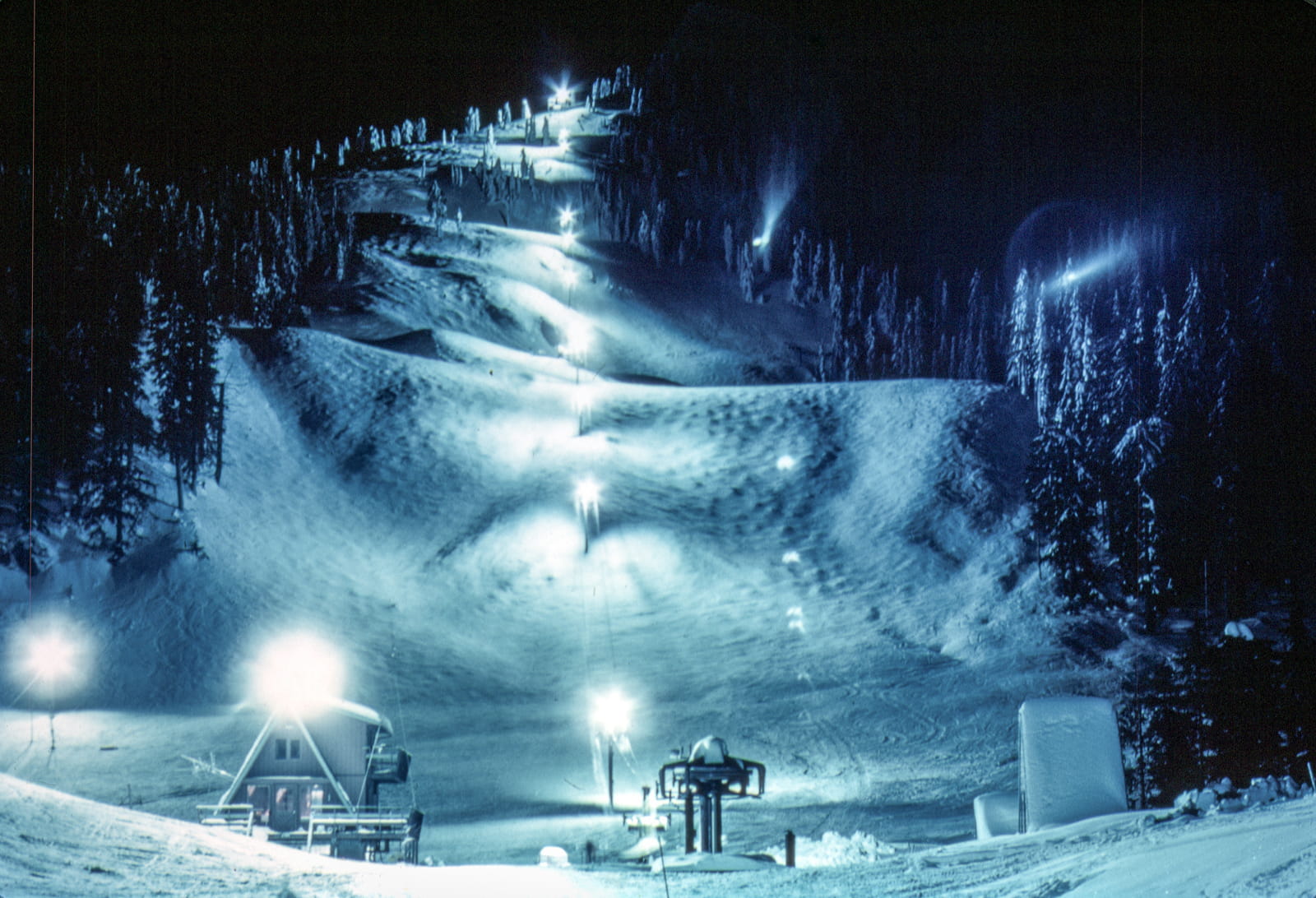 Mt. Pilchuck ski area at night
Today the legacy of the Mt. Pilchuck ski area makes it an excellent contender for the reestablishment of winter access for the following reasons:
- The road to the former ski lodge and parking lot still exists and is used as the current summer trailhead. Moreover, the upper section of this road is paved (although it could use some maintenance).
- The lower portion is not paved, but given the popularity of Heather Lake in the summer and how the Mt. Pilchuck road is in such terribly awful condition the lower portion of it should really be paved regardless.
- This road access to a fairly high trailhead would make restablishing winter access a matter of simply plowing it. And since the lower elevations won’t get much snow and there is, as far as I know, no avalanche danger along the road, this would be a fairly simple task.
- Pilchuck is useful for both ski tourers and snowshowers alike. It has great potential to be useful for multiple forms of winter recreation.
- Its proximity to Everett and Seattle would make it an excellent option for snow access without needing to drive deeper into the mountains.
- It exists in a road corridor that is otherwise sparsely used during the winter. Opening it would divert a small amount of traffic away from the other busy roads.
Conclusions
So where do we go from here? When I started this project I thought it would be a few days of building that map with the elevation band shading and then I would find a bunch of interesting potential ski area locations to write about. Four months and countless hours of research and writing later I have learned that the situation is far more complex and difficult. Our snowpack at higher elevations should hold up for a while but the land use restrictions in the Cascades mean that any new ski area or even meaningful expansion of our existing ski areas will require congressional action to free up a small amount of land for environmentally responsible and sustainable development.
Despite these difficulties and uncertainties, there are some high level proposals that I believe can be realistically made:
- As in the past, the focus for capacity expansions to handle the coming short term population growth is at our existing ski areas. It is far more realistic to expand what is already there than to build new development.
- Additional high elevation show access points should be opened for the purpose of backcountry access for ski touring, snowshoeing, and as snow play areas. Mt. Pilchuck is an excellent location for this but others may work as well, such as plowing more of the North Cascades Highway where feasible.
- The formation of a community group focused on lobbying for access issues that transcends all mountain recreational activities. This would involve winter and potentially summer access issues as well as lobbying for potential changes to laws to ensure we are able to maintain a sufficient amount of access to keep our mountains available for those who use to recreate in them.
- Reviving the seemingly defunct Cascade Backcountry Alliance in cooperation with existing sport-specific community groups would be an excellent first step here.
I have been talking with a few people in outdoor industry in regards to my previous posts on these topics. We have discussed starting a conversation with the existing interest groups on what the problems we face are and how we could collectively go about addressing them. If you share a similar mindset and are interested in participating in that conversation please contact me. My email address is shane@shanetully.com. Or even if you simply have suggestions for where a new ski area could go that I may have overlooked, I’d love to hear about any and all of it.
Any real progress on these access issues is challenging, but certainly not impossible. The example mentioned earlier of Skeetawk in Alaska demonstrates that a new ski area can be opened without corporate money and in a reasonable timeframe. Similarly, a community group recently re-opened the defunct Panadero ski area in Colorado as Cuchara Mountain Park focused specifically on the goal of increasing access to skiing and making it affordable again. I don’t see why something similar in Washington could not be accomplished given the amount of passionate and talented skiers we have here.
Putting aside any uncertainty about what can be achieved, this I am certain: Most ski areas, many here in the PNW, were started by small groups of passionate skiers. They began as simple operations with one or two chairlifts and slowly grew over time to the ski areas we have today. These ski areas only exist because of the passion and drive of the skiers that came before us. We all painfully recognize the problems ski culture in the PNW is facing. You’ll be waiting indefinitely if you’re hoping for the current corporate owners of those ski areas to solve these problems. The only real solution to these problems is for a similarly passionate group to take a community driven approach to create what we collectively view as a better path forward for skiing and winter recreation at large.
See you next winter.
Sources
A special thank you is in order for Lowell Skoog. His book, Written in the Snows, is an incredible summary of the history of skiing in the PNW and is heavily cited here. It is well worth your time to read it if you are interested in these topics. Moreover, his Alpenglow Ski Mountaineering History Project is a wealth of information which my blog posts would not have been possible to write without.
-
Written in the Snows, Lowell Skoog, p80 ↩
-
Kirsten Lynch, Vail Resorts: Using Data to Understand and Reach Customers ↩
-
Final Environmental Impact Statement, White Pass Ski Area Proposed Expansion ↩
-
Written in the Snows, Lowell Skoog, p247 & 248 ↩
-
Avalanches on the North Cascades Highway, Ed LaChapelle ↩
-
Written in the Snows, Lowell Skoog, p246-247 ↩
-
Written in the Snows, Lowell Skoog, p187-189 ↩
-
Written in the Snows, Lowell Skoog, p189 ↩